tóng-àn:Luzon Strait n7184.jpg
跳至導覽
跳至搜尋


先看佔量: 318 × 598 像素. 其他的 kái-sek-tō͘: 127 × 240 像素 | 542 × 1,020 像素.
全解析度 (542 × 1,020 像素,檔案佔量: 77 KB,MIME類型: image/jpeg)
|
|
這是對Wikimedia Commons引來的一份檔案。伊佇hia ê kì-su̍t-ia̍h頂面的資訊顯示對下底. |
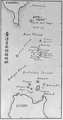
| Soat-bêng | Old map of the Luzon Strait (not labeled), including the Bashi Channel, between Orchid Island (Botel Tobago on the map) of Taiwan and the Batan Islands of the Philippines. Names may be out of date. Japanese caption: "Islands between Taiwan and Luzon". | |||||
| Ji̍t-kî | 日期不明 | |||||
| Chhut-chhù |
From digital archive of the University of Tokyo. [1] Cropped by a-giâu. |
|||||
| Chok-chiá | anthropologist Torii Ryūzō (1870-1953) | |||||
| 授權允准 (Bô siŏh-huòi sāi ciā ùng-giông) |
|


檔案歷史
揤日期/時間,看彼時陣的檔案.
| 日期/ 時間 | 細張圖 | 寸尺 | 用者 | 註解 | |
|---|---|---|---|---|---|
| 現在 | 2004年11月12日 (拜5) 07:30 | | 542 × 1,020(77 KB) | A-giâu | Old map of the Luzon Strait,(not labeled), including the Bashi Channel, between Orchid Island (Botel Tobago in the map) of Taiwan and the Batanes of the Philippines. Names may be out of date. From digital archive of the Universit |
影像連結
以下的頁連到這个影像: