這是一份對Wikimedia Commons引來的檔案

tóng-àn:Viking Expansion.svg

Lohankhapedia (自由的百科全書) 欲共你講..。
跳至導覽 跳至搜尋
全解析度(SVG ùng-giông, chék-cháung: 800 × 524 chuông-só, ùng-giông duâi-nâung:2.92 MB)

Khài-iàu

Soat-bêng
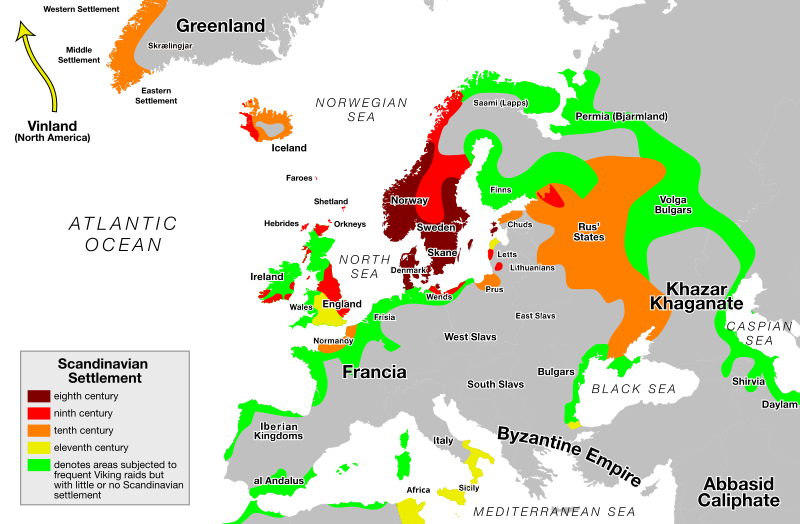
English: Areas subject to settlement and raids by Vikings and Normans:
 
eighth century
 
ninth century
 
tenth century
 
eleventh century
 
subjected to frequent Viking raids but with little or no Scandinavian settlement


Reused by: 40 more maps that explain the world Jan 13, 2014 Washington Post
Ji̍t-kî
Chhut-chhù Ka-tī chò--ê. An SVG version of this image. Based on the blank Europe map available on the Commons.
Chok-chiá Max Naylor
其他版本

[siu-kái]


Siū-khoân

Public domain 此作品已由其作者,I, Max Naylor,釋出至公有領域。此授權條款在全世界均適用。
這可能在某些國家不合法,如果是的話:
I, Max Naylor授予任何人有權利使用此作品於任何用途,除受法律約束外,不受任何限制。

說明

添加單行說明來描述出檔案所代表的內容
Map of Viking expansion in Europe between the 8th and 11th centuries

在此檔案描寫的項目

描繪內容 繁體中文

創作作者 繁體中文

沒有Wikidata項目的某些值

作者姓名字串 繁體中文: Max Naylor

檔案來源 Chinese (Taiwan) (已轉換拼寫)

檔案歷史

揤日期/時間,看彼時陣的檔案.

日期/ 時間細張圖寸尺用者註解
現在2018年2月26日 (拜1) 06:292018年2月26日 (拜1) 06:29版本的細圖800 × 524(2.92 MB)AsmodimAdded the areas of the Norman "Kingdom of Africa" (see article on wikipedia), conquest part of the Norman kingdom of Sicily under Roger II.

以下的頁連到這个影像:

元資料