tóng-àn:1640 Map of Formosa-Taiwan by Dutch 荷蘭人所繪福爾摩沙-臺灣.jpg
跳至導覽
跳至搜尋


先看佔量: 800 × 552 像素. 其他的 kái-sek-tō͘: 320 × 221 像素 | 640 × 442 像素 | 1,024 × 707 像素 | 1,280 × 884 像素 | 8,168 × 5,640 像素.
全解析度 (8,168 × 5,640 像素,檔案佔量: 9.77 MB,MIME類型: image/jpeg)
|
|
這是對Wikimedia Commons引來的一份檔案。伊佇hia ê kì-su̍t-ia̍h頂面的資訊顯示對下底. |
Khài-iàu
| Soat-bêng |
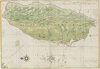
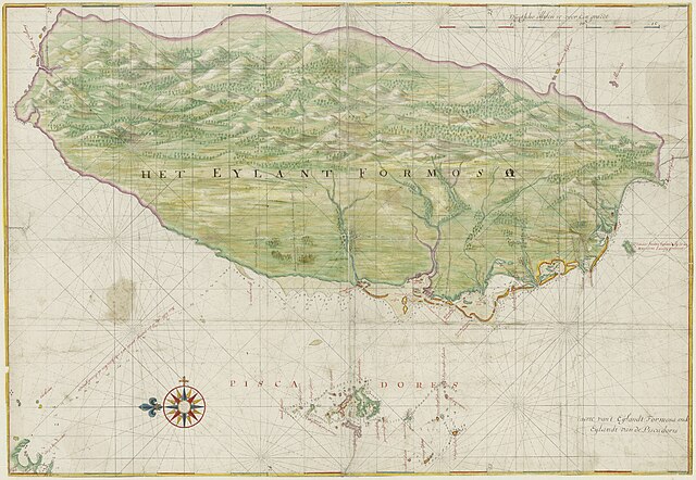
English: The Island Formosa and the Pescadores |
||||||||||||||||||||||
| Ji̍t-kî | 約1640年 | ||||||||||||||||||||||
| Chhut-chhù | Nationaal Archief, Den Haag source. Copied from Chinese Wikipedia. Original source: npm.gov.tw | ||||||||||||||||||||||
| Chok-chiá |
|
||||||||||||||||||||||
| 授權允准 (Bô siŏh-huòi sāi ciā ùng-giông) |
|
||||||||||||||||||||||
| 其他版本 |
|
||||||||||||||||||||||


此標籤不表示文件的著作權狀態。任何文件在附有此標籤的同時還需要一個有效的著作權標籤。請參閱許可協議說明頁面以了解更多資訊。
|
檔案歷史
揤日期/時間,看彼時陣的檔案.
| 日期/ 時間 | 細張圖 | 寸尺 | 用者 | 註解 | |
|---|---|---|---|---|---|
| 現在 | 2021年11月11日 (拜4) 09:13 | | 8,168 × 5,640(9.77 MB) | Tiouraren | Retrieve the rotation since the author had intentionally used this perspective, including labels and mountains. Such direction can also be seen in subsequent maps in Qing era. |
影像連結
以下的頁連到這个影像: