La Chapelle-de-Surieu
跳至導覽
跳至搜尋
| La Chapelle-de-Surieu | |
| — Commune — | |
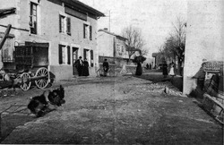 La Chapelle-de-Surieu的景色
|
|
 |
|
 La Chapelle-de-Surieu |
|
| 經緯度: 45°23′28″N 4°54′36″E / 45.39111°N 4.91000°E | |
| 國家 | |
|---|---|
| 大區 | Rhône-Alpes |
| 縣 | Isère |
| 郡 | |
地理 [修改]
人口 [修改]
| 1968 | 1975 | 1982 | 1990 | 1999 | 2007 | 2012 | |
|---|---|---|---|---|---|---|---|
| 人口 | 345 | 289 | 326 | 409 | 477 | 632 | 712 |
| 30.7 | 25.8 | 29.1 | 36.5 | 42.5 | 56.3 | 63.5 |
參考 [修改]
- "Commune de La Chapelle-de-Surieu (38077) - Dossier complet". INSEE. 2016-05-22 khòaⁿ--ê.
連結 [修改]